DroneCamp 2021, July 26-30. More info.
Wed. June 24, 2020
Image Processing Part 2; GIS Analysis Part 1
All times are Pacific Daylight Time
9:00 - 9:50. Data Management and Sharing Results
Data from drone mapping projects are not only huge, but also varied. In addition to the source images, you’re likely to wind up with a far larger volume of intermediate files, a number of 2D and 3D outputs, your metadata, and various GIS/GPS files. How to you manage such an unwieldy collection of data? What do you keep, what can you throw away, and how do you share the results with collaborators?
Format: presentation
Instructor(s): Sean Hogan, Shane Feirer, Andy Lyons
Materials:
Recording:
— Image Processing Pt2 —
10:00 - 11:50. Drone Imagery Processing with Agisoft Metashape
Agisoft Metashape is one of the top processing platforms for drone imagery. This workshop will introduce you to the Metashape GUI and workflow, with hands-on exercises using both RGB and multispectral data. Radiometric calibration and quality checking will be covered, and advanced features including scripting with Python introduced.
Format: hands-on
Instructor(s): Mallika Nocco, Logan Ebert
Pre-requisites: Participants should attend or view the recording of the ‘Intro to Photogrammetry and Data Processing’ session
Additional instructions: To complete this hands-on workshop, you need to have Metashape Professional 1.6.2 installed on your computer, and a working license (a trial license is fine). See Agisoft Metashape on the Computer Setup page for details. You should also download the data (6.7 GB) prior to the workshop.
Materials:
Recording:
10:00 - 11:50. Open Source Data Processing with OpenDroneMap
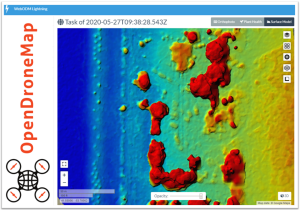
OpenDroneMap (ODM) is a well-developed open-source platform for converting drone images into 2D and 3D outputs. This workshop will explain how to setup and run ODM, modify processing parameters for different types of data and projects, and view the results. During the hands-on section, participants can try running ODM themselves.
Format: hands-on
Instructor(s): Corey Snipes
Additional instructions: To participate in the hands-on section, install the free Windows program called “WebODM Lightning Client”, and also create a free account with WebODM Lightning prior to the workshop. See OpenDroneMap on the Computer Setup page for details.
Materials:
Recording:
— Working with Drone Outputs in GIS Pt1 —
14:00 - 15:50. Multispectral Data Visualization and Extraction with QGIS
A common task for using drone data in research is to extract the pixels for specific plots or plants, so you can then analyze them using zonal statistics and other methods. In this workshop, you’ll learn how to use QGIS, a well-developed open source desktop GIS program, to visualize and analyze processed drone data. The final portion of the workshop will include a demonstration on how to integrate R scripts into QGIS for high-throughput phenotyping.
Format: hands-on
Instructor(s): Taylor Nelsen
Pre-requisites: This workshop is for beginners and requires no background with QGIS
Additional instructions: To complete this hands-on workshop, you need to have QGIS installed on your computer. See Computer Setup for details. You should also download the data prior to the workshop.
Materials:
Recording:
14:00 - 15:50. Mapping and Analyzing Drone Data in ArcGIS Pro
After you’ve stitched your images together, you’ll probably want to analyze them further or add them to maps for better visualization. The session will introduce you to one of the leading desktop GIS platforms, ArcGIS Pro, and show you how to work with orthomosaics and DSM surfaces. No experience with ArcGIS Pro is needed, but new-comers are encouraged to work through an online getting started tutorial. This workshop is a pre-requisite for the ‘Analyzing Vegetation with ArcGIS Pro’ workshop on Thursday June 25.
Format: hands-on
Instructor(s): Shane Feirer, Robert Johnson, Chippie Kislik
Additional instructions: To complete this hands-on workshop, you need to have ArcGIS Pro installed on your computer, and a working license. See ArcGIS Pro on the Computer Setup page for details. You should also download the data prior to the workshop.
Materials:
Recording: